
Urban Design / Livability
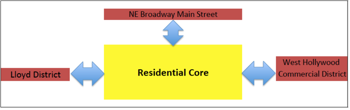
SGN is designed around a central residential core that is adjacent to service districts that lie to the east, north, and south. The aim of the neighborhood plan is to reinforce this urban design framework. The following pages summarize urban design issues that impact interactions between these neighborhood features and solutions that we hope to implement over time.
Figure 2 – Urban Design Orientation
Figure 2 – Urban Design Orientation
Design Compatibility
The neighborhood will develop ‘design guidelines’ to help ensure infill and redevelopment is compatible with the neighborhood. The concern is less with historic architectural styles, which vary, and more with design that is oriented to the pedestrian environment. New residential buildings should match the setback of adjacent structures and include porches, stoops, courtyards, and balconies. Buildings on NE Broadway need to emphasize pedestrian accessibility and convenience.
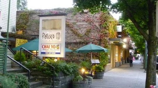
NE Broadway Main Street
Between the commercial hub at NE 15th Avenue in Irvington and the NE 40th Avenue gateway to Hollywood is a 1.5-mile corridor without a center. There are a number of intersections in this reach with potential to become a focal point, including the mid-point intersection at NE 28th Avenue. The zoning through the corridor is uniform and emphasizes mixed-use development. We seek to establish service node in the east-end of the corridor with corner-facing entryways that support walk-in trade similar to the node at NE 15th Avenue. Design guidelines and creative use of public right of way are needed to enhance accessibility for pedestrians.
The neighborhood will develop ‘design guidelines’ to help ensure infill and redevelopment is compatible with the neighborhood. The concern is less with historic architectural styles, which vary, and more with design that is oriented to the pedestrian environment. New residential buildings should match the setback of adjacent structures and include porches, stoops, courtyards, and balconies. Buildings on NE Broadway need to emphasize pedestrian accessibility and convenience.
NE Broadway Main Street
Between the commercial hub at NE 15th Avenue in Irvington and the NE 40th Avenue gateway to Hollywood is a 1.5-mile corridor without a center. There are a number of intersections in this reach with potential to become a focal point, including the mid-point intersection at NE 28th Avenue. The zoning through the corridor is uniform and emphasizes mixed-use development. We seek to establish service node in the east-end of the corridor with corner-facing entryways that support walk-in trade similar to the node at NE 15th Avenue. Design guidelines and creative use of public right of way are needed to enhance accessibility for pedestrians.
Plan – Zoning Inconsistency
The Portland Plan includes designations that allow higher intensity development on NE Weidler between NE 15th and NE 21st Avenues that differs from the existing zoning. The cost, complexity, and time it takes to rezone these properties impedes redevelopment. The neighborhood advocates a voluntary city-wide rezoning program for owner-occupied single-family properties in mixed-use corridors to incent redevelopment and add affordable housing in transit corridors.
Non-conforming Uses
East of NE 21st Avenue there are many multi-family properties that do not conform to the R-2.5 residential zone. In some blocks virtually all of the structure are non-conforming. These properties provide some of the most affordable housing in the inner city. There is a risk that they could fall into disrepair if replacement were prohibited or that affordable housing inventory could be lost if owners elected to redevelop to the base-zone density. A planning framework is needed to resolve this issue. See Figure 3 below.
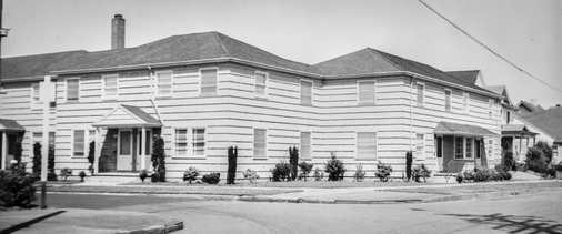
Figure 3 – Non-conforming Development
Goals/Actions
- Develop design guidelines for residential and commercial infill by 2021. Sources to consider include the Albina Plan Design Compatibility Guidelines, Division Street Design Project, and Portland’s Design Overlay Guidelines.
- Jointly prepare location and design recommendations for a NE Broadway service hub with the Grant Park Neighborhood Assn. by 2020.
- Work with NECN and other neighborhood coalitions to develop a city-wide framework to reduce cost and incent redevelopment of single family properties in corridors whose zoning is inconsistent with the Portland Plan.
- Reduce non-conforming uses east of NE 21st Avenue through a combination of regulatory changes and redevelopment incentives.
All Chapters |
Next Chapter: Transportation |