Transportation
Overview
The automobile is currently the neighborhood’s primary transportation mode. If our neighborhood is to effectively combat climate change, then we need to invent the use of alternative transportation modes. People should not feel the need to encase themselves in 3000 pounds of steel to travel a few blocks.
Sullivan’s Gulch could be a mostly car-free neighborhood. It was platted at a time when there were no cars. The terrain is relatively flat. It has an excellent pedestrian framework. All residences are within easy walking and biking distance to the Central City and neighborhood service districts. A major off-street bike trail is envisioned within Sullivan’s Gulch. The neighborhood has excellent transit service. High frequency east/west bus service is in place on NE Broadway/Weidler. A new north/south bus route is planned from Sellwood to the Dekum Triangle. The MAX light rail station at Holladay Park is within walking distance.
Safety concerns impede greater bike and pedestrian use. Portland’s Vision Zero initiative revealed that the NE Broadway corridor has the #1 crash rate for bikes, the #5 crash rate for pedestrians, and the #14 crash rate for automobiles. Crossing improvements and speed control measures are need to make walking and biking to neighborhood destinations safer.
Broadway/Weidler Corridor Enhancements
NE Broadway Boulevard is the neighborhood’s ‘Main Street’ but getting to Broadway on foot is challenging. The Portland Pedestrian Plan calls for crosswalk spacing not less than 350 feet in major corridors. The block spacing in the Broadway-Weidler Corridor is >400’ between NE 17th Avenue and NE 24th Avenue. There are bus stops at NE 19th, NE 22nd and NE 24th. None of these intersections has a crosswalk.
Traffic speed is a concern. Pedestrians are intimidated by the speed of approaching traffic on NE Broadway west of NE 24th Avenue and on Weidler between NE 21st and NE 24th Avenues.
Pedestrian crossing safety improves on Broadway east of NE 24th Avenue but the street is unsafe for bikes. There is not enough road width on Broadway east of NE 24th Avenue to accommodate vehicle lanes, bike lanes, and on-street parking.
Goals/Actions:
Pedestrian Safety
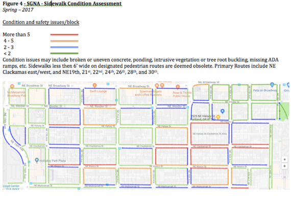
Most neighborhood trips could be made without driving but there still is heavy reliance on cars, even for short trips. Safer pedestrian crossings are needed on Weidler and Broadway, and on 16th, 21st, and 28th Avenues. Most sidewalks in the neighborhood are approaching 100-years old. Sidewalks on some blocks are narrow, especially Clackamas east of NE 24th Avenue. Settling has occurred with cracking and seasonal ponding.
Figure 4 shows sidewalk conditions as of Spring 2017.
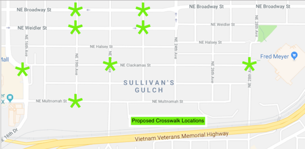
Figure 5 shows proposed locations for crosswalks.
Poor visibility is a challenge for pedestrians after sunset. Private lighting illuminates sidewalks in places but is inconsistent. Pedestrian scale lighting is needed on primary routes to help reduce car trips.
Recommendations:
The automobile is currently the neighborhood’s primary transportation mode. If our neighborhood is to effectively combat climate change, then we need to invent the use of alternative transportation modes. People should not feel the need to encase themselves in 3000 pounds of steel to travel a few blocks.
Sullivan’s Gulch could be a mostly car-free neighborhood. It was platted at a time when there were no cars. The terrain is relatively flat. It has an excellent pedestrian framework. All residences are within easy walking and biking distance to the Central City and neighborhood service districts. A major off-street bike trail is envisioned within Sullivan’s Gulch. The neighborhood has excellent transit service. High frequency east/west bus service is in place on NE Broadway/Weidler. A new north/south bus route is planned from Sellwood to the Dekum Triangle. The MAX light rail station at Holladay Park is within walking distance.
Safety concerns impede greater bike and pedestrian use. Portland’s Vision Zero initiative revealed that the NE Broadway corridor has the #1 crash rate for bikes, the #5 crash rate for pedestrians, and the #14 crash rate for automobiles. Crossing improvements and speed control measures are need to make walking and biking to neighborhood destinations safer.
Broadway/Weidler Corridor Enhancements
NE Broadway Boulevard is the neighborhood’s ‘Main Street’ but getting to Broadway on foot is challenging. The Portland Pedestrian Plan calls for crosswalk spacing not less than 350 feet in major corridors. The block spacing in the Broadway-Weidler Corridor is >400’ between NE 17th Avenue and NE 24th Avenue. There are bus stops at NE 19th, NE 22nd and NE 24th. None of these intersections has a crosswalk.
Traffic speed is a concern. Pedestrians are intimidated by the speed of approaching traffic on NE Broadway west of NE 24th Avenue and on Weidler between NE 21st and NE 24th Avenues.
Pedestrian crossing safety improves on Broadway east of NE 24th Avenue but the street is unsafe for bikes. There is not enough road width on Broadway east of NE 24th Avenue to accommodate vehicle lanes, bike lanes, and on-street parking.
Goals/Actions:
- Traffic signals and/or controlled crosswalks are needed at NE 17th, 19th, and 22nd Avenues on both Weidler and Broadway. Include in the next TSP update.
- Design a new east/west bike circulation routing that could include two-way cycle tracks and routing on parallel residential streets east of NE 24th Avenue. Include in the next TSP update.
- Advocate a thorough analysis for decoupling the one-way couplet and alternative routing for bikes and transit on NE Broadway and Weidler. Update the Broadway-Weidler Corridor Plan by 2020.
- Pursue funding for Broadway traffic conversion, safety enhancements, street furniture and street trees by 2021.
Pedestrian Safety
Most neighborhood trips could be made without driving but there still is heavy reliance on cars, even for short trips. Safer pedestrian crossings are needed on Weidler and Broadway, and on 16th, 21st, and 28th Avenues. Most sidewalks in the neighborhood are approaching 100-years old. Sidewalks on some blocks are narrow, especially Clackamas east of NE 24th Avenue. Settling has occurred with cracking and seasonal ponding.
Figure 4 shows sidewalk conditions as of Spring 2017.
Figure 5 shows proposed locations for crosswalks.
Poor visibility is a challenge for pedestrians after sunset. Private lighting illuminates sidewalks in places but is inconsistent. Pedestrian scale lighting is needed on primary routes to help reduce car trips.
Recommendations:
- Crosswalks and possibly rapid flashing beacons on NE Clackamas at NE 16th, NE 21st, and NE 28th Avenues.
- Crosswalks and traffic signals or rapid flashing beacons on NE 17th, NE 19th, NE 22nd, and NE 24th Avenues at NE Weidler and Broadway Streets.
- A crosswalk at NE 28th and Weidler to connect the walkways through the green space and the store parking lot.
- Sidewalk replacement/enhancement program focusing on primary pedestrian routes.
- A pedestrian lighting program focusing on primary pedestrian routes.
Figure 5 – Proposed Pedestrian Crosswalk
Bike Routes
Sullivan’s Gulch is well served by bike routes but two are dangerous. The Broadway / Weidler Corridor is documented to be the most dangerous bike route in the city. This east/west route serves local and commuter bike traffic through Lloyd, Elliot, Sullivan’s Gulch, Irvington, and Grant Park.
A second concern is NE 21st Avenue between NE Broadway and NE Multnomah. This important cycling route connects the Tillamook Greenway in Irvington and the Ankeny Greenway in Kerns.
Solutions may include:
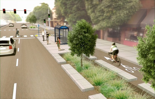
- Protect bike lanes on Broadway as shown below.
- Develop parallel bike routes on NE Weidler and/or NE Schuyler between NE 24th and NE 37th Avenues.
- Reduce the speed limit on NE 21st Avenue between Broadway and Multnomah so that bikes can share the travel lane. Alternatively, remove parking and install bike lanes on NE 21st, or extend the two-way cycle-track on the east side of NE 21st and retain parking on the other.
- The Sullivan’s Gulch Trail is envisioned as a regional bike/ped facility running parallel to I-84 in the Gulch. There is no design for this facility. Access to the trail is recommended from Lloyd Blvd near NE 16th Avenue, and at the NE 21st, NE 28th, and NE 33rd Avenue bridges.
Driving Alternatives
SGNA seeks to replace auto trips with bike, walking, and transit trips. To incent car-free travel in the neighborhood, the following strategies are recommended.
SGNA seeks to replace auto trips with bike, walking, and transit trips. To incent car-free travel in the neighborhood, the following strategies are recommended.
- Adopt design guidelines that include space for car share/taxi loading for development in multi-family and mixed-use zones.
- Enhance rental car services in the neighborhood.
- Enact a transit pass program for neighborhood residents and improve weather protection at bus stops.
- Extend the Bike Town boundary to include SGN.
Parking
City policy to expand affordable housing allows high-density development with limited or no parking. This will impact the on-street parking supply unless more residents choose not to own cars. Commuters and construction workers who park in the neighborhood during the day affect the parking supply.
Strategies to address parking shortages include:
Transportation Goals/Actions
Transit
Bus Service
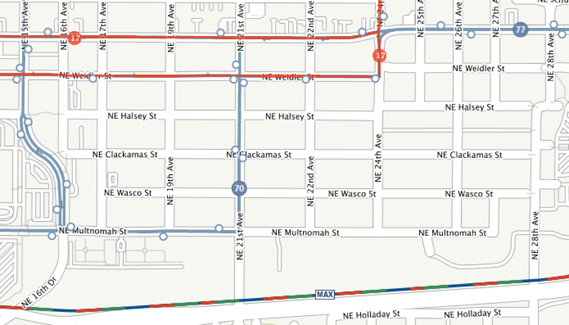
Three bus routes serve Sullivan’s Gulch. Figure 7 shows existing bus routes and stops.
Figure 7 - Transit Service
City policy to expand affordable housing allows high-density development with limited or no parking. This will impact the on-street parking supply unless more residents choose not to own cars. Commuters and construction workers who park in the neighborhood during the day affect the parking supply.
Strategies to address parking shortages include:
- Create a parking district to preserve limited on-street supply for residents.
- Offer transit passes, car share membership, and bike share membership at reduced cost, especially for residents that do not own cars.
Transportation Goals/Actions
- Invest in alternative mode infrastructure so that Sullivan’s Gulch may become the Portland neighborhood with the lowest automotive use and ownership.
- Form a work group to investigate incentives for transit, bike share, car share, taxi, and other alternative transportation service options in conjunction with other inner-city neighborhoods.
- Develop direct safe access to neighborhood services destinations for non-auto users.
- Work with the PBOT to implement City policies and invest in pedestrian safety enhancements with an emphasis on routes to neighborhood service districts.
- Work with PBOT to develop neighborhood-based financing tools for addressing sidewalk safety and pedestrian lighting needs.
- Work with PBOT to resolve bike route safety concerns on NE 21st Avenue and Broadway/Weidler as part of the Broadway/Weidler Corridor Plan Update.
- Work with PBOT to establish one or more residential parking districts in Sullivan’s Gulch.
Transit
Bus Service
Three bus routes serve Sullivan’s Gulch. Figure 7 shows existing bus routes and stops.
Figure 7 - Transit Service
Note: Red lines indicate frequent service routes. Blue circles indicate stops.
Consolidating bus stops may improve service reliability. Pedestrian crossings are needed near all bus stops. The #70 route may be extended south to Selwood via 20’s avenue blocks. SGNA supports this proposal.
MAX Service
SGN favors construction of a subway through downtown beginning at portals in Sullivan’s Gulch. A subway would be less susceptible to seismic risk than the Steel Bridge. Holladay Park may be a suitable construction staging area for the subway with a station beneath the park.
The neighborhood supports a MAX station at NE 28th Avenue. This stop would not compromise travel time if a subway is built through downtown. A station at NE 28th would be next to a major shopping district serving downtown and east-side transit riders.
Streetcar Service
SGNA does not favor streetcar expansion to Hollywood on NE Broadway. We support streetcar expansion to Hollywood through the warehouse district on the south side of I-84.
The existing MAX tracks in the Lloyd District should be considered for streetcar use once the subway is in service.
Transit Goals/Actions
Sullivan Street Freight Crossing
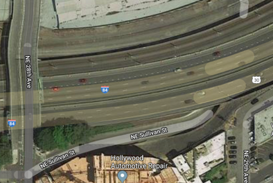
The only at-grade freight crossing on the BNSF line between I-205 and the river is at Sullivan Street in Sullivan’s Gulch. Sullivan Street goes under I-84 to provide access from south of the freeway to a small industrial area. This area can be served from the north via NE 30th Avenue, which would eliminate the need for the at-grade crossing. Access via the Sullivan Street underpass should be maintained for emergency use only. This would eliminate the need for sounding railroad warning horns at Sullivan Street, eliminating a significant noise source.
Goals/Actions:
MAX Service
SGN favors construction of a subway through downtown beginning at portals in Sullivan’s Gulch. A subway would be less susceptible to seismic risk than the Steel Bridge. Holladay Park may be a suitable construction staging area for the subway with a station beneath the park.
The neighborhood supports a MAX station at NE 28th Avenue. This stop would not compromise travel time if a subway is built through downtown. A station at NE 28th would be next to a major shopping district serving downtown and east-side transit riders.
Streetcar Service
SGNA does not favor streetcar expansion to Hollywood on NE Broadway. We support streetcar expansion to Hollywood through the warehouse district on the south side of I-84.
The existing MAX tracks in the Lloyd District should be considered for streetcar use once the subway is in service.
Transit Goals/Actions
- Support frequent service on the #17 and 77 bus routes.
- Support extending the #70 bus route to provide transit service to other east-side main streets.
- Support consolidation of bus stops on the #70 bus route to improve service reliability as follows:
- Eliminate stops on NE 21st at Weidler in favor of stops on NE 21st at Clackamas.
- Shift the stop at NE 22nd to the east side of the intersection and close the stop at NE 24th and Weidler.
- Close the stop on Multnomah near NE 21st Street and establish paired stops on Multnomah at NE 19th Avenue.
- Shift the west-bound stop on Multnomah at NE 16th Avenue to the west side of the intersection.
- Support planning for a downtown subway beginning in Sullivan’s Gulch.
- Support a new Street Car line through the warehouse district south of I-84.
Sullivan Street Freight Crossing
The only at-grade freight crossing on the BNSF line between I-205 and the river is at Sullivan Street in Sullivan’s Gulch. Sullivan Street goes under I-84 to provide access from south of the freeway to a small industrial area. This area can be served from the north via NE 30th Avenue, which would eliminate the need for the at-grade crossing. Access via the Sullivan Street underpass should be maintained for emergency use only. This would eliminate the need for sounding railroad warning horns at Sullivan Street, eliminating a significant noise source.
Goals/Actions:
- Work with development interests and the Kerns Neighborhood to eliminate the need for train horns to sound at the Sullivan Street Crossing.
All Chapters |
Next Chapter: Housing |

